Flood fury: why Uttarakhand, Assam, J&K & Mumbai will be hit again. And what can be done


Hard facts
- Flood alerts have been issued, yet again, for Gujarat, J&K, Assam, Uttarakhand and Mumbai.
- The last four have seen repeated and devastating floods every year, causing deaths, loss of property.
- Flooding is natural. You can\'t prevent floods. Point is, how do you stop them from turning into disasters?
- Three common reasons for flood disasters: increased frequency of extreme weather. Chronic misunderstanding of natural water systems. Irresponsible development.
Tampering with facts
- Every river has a natural water absorbing system around it: wetlands, flood plains, forests, mangroves, streams, ponds.
- These could be called Archimedes\' bathtubs. They look half-full but fill up and absorb excess rain.
- These natural drainage systems have been destroyed by development.
- We build embankments to contain floods. But embankments narrow down rivers, increase silting, make rivers rise.
- Unplanned hydropower projects and dams tamper the most with the course of a river.
- In a nutshell: we are putting impenetrable concrete obstacles in the way of the natural path of water.
More in the story
- Specific causes of floods in J&K, Assam, Mumbai and Uttarkhand explained.
- Solutions outlined.
In the last month alone, flood alerts have been issued for Gujarat, Jammu & Kashmir, Assam and Uttarakhand. Mumbai flooded too, as it has every year in recent memory, but that has now become so routine as to no longer merit an alert.
Every monsoon, like clockwork, reports of floods around the country fill the news. We get death-tolls, property damage assessments, aerial photographs of inundation, and relief allocation announcements from state and centre.
And then? Business as usual. Till the next round, the following year (or later in the season).
Why is this happening so often? Is it inevitable? Can anything be done to prevent or mitigate this cycle of disaster?
Deja vu of despair
In recent years, four problem areas, in particular, have seen recurring damage:
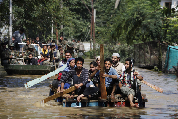
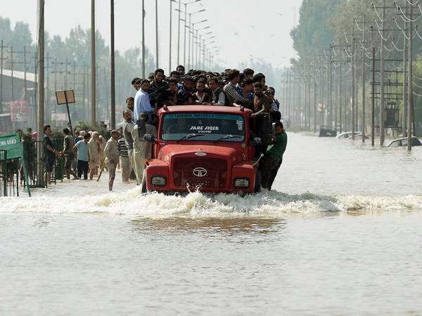
In the Kashmir valley floods last September, 300 people died, 2.60 lakh houses and 75,000 business establishments were damaged. In March this year, the valley began flooding again. In the past week, heavy rainfall and rising water levels in the Jhelum caused the inundation of low-lying villages, landslides and the suspension of rail traffic.
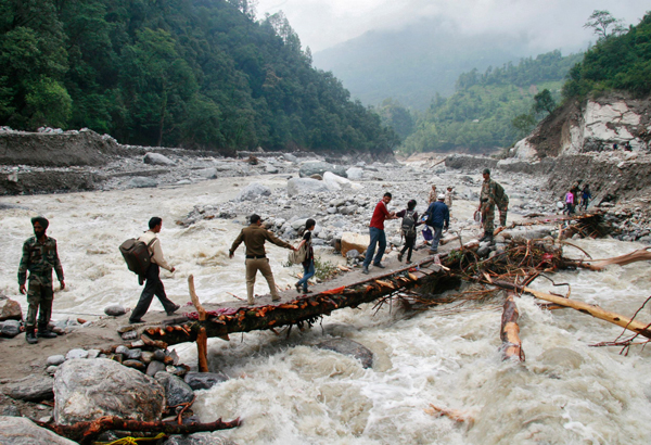
The Uttarakhand floods in June 2013 caused 5,700 deaths and more than Rs 10,000 crore worth of economic losses. In the past week, there have been reports of bridges and roads suffering heavy damage in Rudraprayag district. Rescue operations are underway for over 9,000 stranded pilgrims.
In 2012, Brahmaputra flooding in the Northeast killed 124 people and displaced nearly six million, most of them in Assam. The following year, a lakh of people were affected by floods in the state. This year, Assam began flooding at the beginning of June, and by 13 June, according to the State Disaster Management Authority, more than 3 lakh people had been affected.
On 26 July 2005, Mumbai experienced one of the most intense bouts of rainfall on record: 990 mm in 24 hours. The water accumulated and did not drain for days. Nearly 500 people died. The city came to a standstill. This pattern has repeated, with varying degrees of intensity, nearly every year since. Floods have become part of the city's annual rhythm.
Rainfall can't be helped - disaster can
"Flooding is natural," says Himanshu Thakkar, water expert and coordinator of the South Asia Network for Dams, Rivers and People. "You can't prevent floods. The point is: at what point does the flood turn into disaster, and how can you prevent that disaster?"
That certain parts of the country are seeing floods turn into disasters year on year is no coincidence. The repetition speaks to a pattern, created by the intersection of three persistent problems: the increased frequency of extreme weather due to climate change, a chronic misunderstanding of natural water systems, and irresponsible development of landscapes.
The tendency in media and government has been to explain these flood-disasters as due solely to extreme rainfall events, but this is an incomplete understanding.
Data does not support the argument that flood disasters are due to changes in rainfall patterns, says Amitangshu Acharya, programme manager for South Asia at Akvo, an international non-profit that generates data on water and sanitation.
You can't prevent floods. The point is: at what point does the flood turn into disaster, and how can you prevent it
"We looked at Uttarakhand rainfall over the last 100 years and saw that [the kind of extraordinary rainfall we saw in 2013] has happened six-seven times, but never resulted in floods of this nature."
The scale of disaster, Acharya says, has to do with "how we have been developing landscapes."
Rainfall of extraordinary intensity need not necessarily result in a flooding disaster. Natural drainage systems are amazingly absorbent and adaptable. Left alone, they might be able to manage a freak rainfall every half-century.
But the way in which landscapes are developed and built up is severely impairing the ability of these natural drainage systems to function.
For instance, Acharya says, "Vashi [in Mumbai] has come up completely on a natural drainage zone. Water can't leave easily. That's why there's flooding."
Nature's own water management system
When we talk about a 'natural water drainage system', we're talking about the way that any given landscape manages rainfall. This system involves ponds, lakes, wetlands, mangroves, forests, open areas and streams that work together to absorb or contain water, helping it find its way - steadily - into the ground or a water body.
Rishi Aggarwal, a Mumbai-based environmental activist and researcher with the Observer Research Foundation, has a great analogy to explain this system - Archimedes' bathtub.
The ancient Greek scholar Archimedes famously shouted 'Eureka!' when, sitting down in his bathtub, he noticed the water level rise and inferred that the volume of displaced water must be the same as that of his body.
"Our ponds, lakes, mangroves and even playgrounds are like these bathtubs," says Aggarwal. "During the dry months, they may be half full, but during monsoons, they become 100% full."
These 'bathtubs' - or sponges, if you like - constitute the water-holding capacity of a landscape.
"When you have more water holding capacity," says Himanshu Thakkar, "whether through wetlands or forests or water bodies, rainfall won't lead to floods, because a lot will be absorbed by these natural mechanisms."
These natural water containers are supported by a complex network of streams, which take the water where it needs to go - both feeding it into accommodating water bodies and draining it away from overfull ones, as needed.
Rivers are dynamic, embankments are not. They trap silt, narrow a river, reduce its water-carrying capacity
Additionally, when it comes to a river basin, a river's natural flood plains accommodate its seasonal expansion, besides allowing it to disperse and find its way around silt.
The trouble, as Amitangshu Acharya pointed out, is that we are building up our landscapes without any regard to the ways in which water systems naturally function, or how we might be disrupting them.
Whether you look at Mumbai or the Kashmir valley, the river basins of Uttarakhand or Assam, the story is the same.
Not only are we compromising the natural systems that manage water - by eating into forest cover, encroaching on flood plains, damming rivers, choking waterways with construction and mining debris and trash - we have also put an impenetrable concrete obstacle course in the way of water's natural paths.
Mumbai: failures of ecology and engineering
In Mumbai, says Rishi Aggarwal, "Concretisation is interfering with groundwater, and with the storm water drainage system."
"If you look at the Lower Parel mill land area - the old mills used to have a significant area of open land. The ground below was reasonably porous. All of these mills had large ponds. Now, a severe degree of concretisation has taken place. Some buildings have three layers of basement. The boundaries of compounds are encased in concrete."
For a high-rainfall city like Mumbai, every open area, every little patch of open ground between roads and buildings, every pond, park and stream, counts as a sponge, crucial for its natural drainage system.
"If a pond is able to contain 1 lakh cubic metres and you build a building over it, the neighbourhood will lose that amount of absorption potential."
The volume of water that would have been contained by that pond will end up in the street, where it will stagnate, because urban storm water drains - and natural ones like the Mithi river, which was a major force behind the flooding in 2005 - are clogged with sewage and solid waste.
"Fifty per cent of Mumbai is slums," says Aggarwal. "They don't have proper sewage systems. Their sewage is going into the storm water drainage system around the year. But in the monsoons, the sewage and rainwater together overwhelm the drainage systems." So there's rainwater and sewage in the street, blocked from draining away by garbage and concrete.
Aggarwal says Mumbai's annual inundation is a combination of two kinds of failure: failures of ecology and engineering. One one hand, the disruption of the city's natural drainage systems, and on the other, the inefficacy of the city's urban drainage infrastructure.
In this context, protecting the city's remaining 'bathtubs' becomes doubly important. Their value is utterly tangible.
During the 2005 floods, says Aggarwal, Lokhandwala complex didn't face the same kind of flooding the rest of the city did. This is because water was able to drain into the 200 acres of mangroves at the periphery of that area. Aggarwal himself was very active in the campaign to save those mangroves between 1999 and 2002.
Thanks to those mangroves, he estimates that up to Rs 5 crore in insurance premiums were saved on 26 July 2005. That's not counting all the property damage and loss of business saved. Plus, he says, "mangroves don't require a municipal maintenance budget."
Kashmir: Throwing good concrete after bad
Lessons from Mumbai would be valuable for the rapidly urbanising Kashmir valley. Though the geography is different, the patterns of ecological damage and planning failures look to be similar.
In the valley, says Himanshu Thakkar, "the area under wetlands has gone down. The water holding capacity of the Dal lake has gone down. Rivers and waterways have gotten silted up and their water carrying capacity has gone down. In the catchment area [or drainage basin], forest cover has gone down."
What all of this adds up to is a drastic reduction in the region's overall capacity to hold and carry rainwater. So when there is heavy rainfall, wetlands can't absorb as much, denuded hillsides can't stagger the descent of water or keep it from carrying vast quantities of silt into the river, the rivers can't carry as much and the lakes can't hold as much. Hence: floods.
Plus, says Anuradha Bhasin Jamwal, Executive Editor of the Kashmir Times, "people have encroached upon catchment areas around [the Jhelum and the Dal lake], and have built hotels, tourist shacks, posh residential colonies."
"Whenever there have been PILs [against this kind of encroachment], the courts have directed authorities to crack down," says Jamwal, "but authorities will only crack down on the poor and slum-dwellers. Encroachments by influential people become regularised."
As in Mumbai, such ad-hoc construction ends up blocking off natural drainage channels, and results in water becoming trapped.
"The reason there was a flood again in March," explains Himanshu Thakkar, "was because the flood water that had spread in September had not yet drained out. That water was still there, and [with a fresh round of rains] more water came in."
The government's proposed solution to the flooding in the Jhelum basin is an 80 km-long flood spill channel, which would divert excess water from the Jhelum at Dogripora to Wular lake, further north.
This plan is in recognition of the fact that the combined water carrying capacity of the Jhelum (estimated at 35,000 cusecs) and that of the existing flood channel (12,000 cusecs) were not sufficient to manage the estimated 1 lakh cusecs of water that passed through the Jhelum last September.
The new flood spill channel is to have a capacity of 55,000 cusecs. Its estimated cost is Rs 20,000 crore. Building it will probably also require quite a bit of land.
This has a kind of perverse irony. Construction has damaged the Jhelum river basin's natural flooding and draining mechanisms; more construction is now being called for to provide it with an artificial replacement.
Uttarakhand: Getting in the water's way
In Uttarakhand, says Lalit Pandey, director of the Uttarakhand Seva Nidhi Paryavaran Shiksha Sansthan, development in the low-lying river flood plains is rampant.
"Land is very scarce in the hills, especially flat land," he says. "So the temptation is to just build [in the river valleys]. There may be proper land higher up, that may be better because you would have solid rock foundation [to build on], but it is classified as forest land, so they can't do anything there."
New projects usually come up close to roads. And roads are usually constructed along rivers, "because it is cheaper and easier to build in the valleys than along the ridges. Pilgrimage routes to Badrinath and Kedarnath are also built along the river."
As a result, all the infrastructure to support surging tourism - casual and religious - is crowding up the river basin. As we've already established, this massively disrupts natural water drainage systems. But it's also a self-defeating exercise, because, besides being inside the river's flood zone, it's all built on unsteady ground, and so doubly vulnerable to damage.
"The riverbed is silty, unsteady ground to build on," says Pandey, "but now that you have new materials like concrete, you can build anywhere. Earlier, it would have been impossible to build a six-seven storey building so close to a river bed."
Human dwellings near water bodies with reduced carrying capacity are a risky proposition indeed. To manage this risk, embankments are built. But not only are embankments ineffective at mitigating really big floods, they forcibly narrow a river, reducing its carrying capacity further.
It's a full circle: you build too close to a river, so you build embankments to protect yourself from flooding, but the embankments narrow the river, so it can't hold high volumes of rainwater in monsoon, leading to - you guessed it - flooding.
Assam: Outwitting geography
Speaking about flooding in Assam, Mrinal Gohain, regional manager for Actionaid, laments the loss of a lifestyle that was built to suit the region's 'riparian topography' - where flooding in fact is a natural part of the seasonal cycle.
"The Mishing community had this perfect adaptation to the environment. Before the floods, they would plant the rice. The flood watered the seed and it grew. They lived on houses on stilts."
In other words, there was an adaptation to the local environment, rather than an effort to resist it. But in the decades following Independence, says Gohain, plans to develop the region were set into motion.
"Development projects came up, factories came up, there was massive deforestation." But very little thought was spared for flood resistance, for adapting to the region's water reality.
Here, too, embankments were thought to be a solution. But, as Gohain points out, "rivers are dynamic, embankments are not. As the volume of silt grows and the river bed rises, the river shapeshifts. Embankments make that impossible."
Besides, "it's not like the embankments are doing their job very well. The idea is to contain the river. But if you have a big wall, where will the water go?"
"An embankment only transfers water downstream," says Himanshu Thakkar. "It stops the link of the river with the flood pains, and interferes with tributaries. If you build embankments on rivers, you must then build them on tributaries. Then what happens to streams?"
When there were no embankments in Assam, says Thakkar, water would spread over a large area and so would the silt. But when you narrow the river, the silt is trapped, the river bed rises, and the carrying capacity of the river is reduced.
"The Brahmaputra is the highest silt-carrying river in the world," says Thakkar. "If it is not able to carry the silt, it will deposit it on the river bed. It is also a highly eroding river. It has a very wild flood plain, and a meandering, course-changing habit. It also has the 3rd or 4th highest water carrying capacity [of any river in the world]."
So you have a swollen river, hemmed in by embankments, made shallow by silt-stuffed riverbeds. Add a healthy monsoon, and it simply spills over. Embankments, then, seem not only redundant, but somewhat counterproductive - as indeed are most efforts to interfere with a river's natural course.
Inviting even more trouble
Perhaps the greatest disruption of a river's natural water system are big dams and hydropower projects. Jammu & Kashmir, Uttarakhand and Assam have this problem in common, as all three states are estimated to have high potential for hydropower.
Indiscriminate damming and tunnelling of rivers for hydropower plants in all three states has led to massive disruptions of riparian systems, impairing their ability to cope with extreme weather brought on by climate change.
"When you build hydropower projects," says Himanshu Thakkar, "you have deforestation, blasting, tunnelling, diversion of the course of the river. All these things add to the flood potential of the area. By building these projects, we are inviting even more trouble."
The Himalayan region, Thakkar explains, is already prone to erosion and landslides. Add deforestation, plus the blasting it takes to create tunnels for run-of-the-river hydropower projects, and you only aggravate those tendencies.
Erosion and landslides both contribute heavily to the accumulation of silt in rivers and water bodies. And silt not only reduces their water holding capacity, it also makes floods more damaging, as was made amply evident in Uttarakhand in 2013.
After the floods, the Supreme Court had put a stay on 24 proposed hydropower projects in the state. And in December 2014, the Ministry of Environment and Forests admitted to the Supreme Court that the floods had been aggravated by the glut of hydropower projects in the state's river basins.
Based on what we know about the impact of hydropower projects in Uttarakhand - besides flash-floods, landslides and disruption of water flow downstream, there's also massive damage to biodiversity - it is not unreasonable to infer similar impacts in other river basins.
The number of projects - existing and planned - on the Jhelum, Chenab and especially the Brahmaputra (which has the highest hydropower potential of any river in the country) should be cause for great concern.
Especially because the full scale of the cumulative impact of these projects on each river's health is not yet known, which is why so many experts and activists are pushing for assessments to be conducted.
Suggested solutions
Floods, Himanshu Thakkar reiterates, cannot be stopped. But the damage they cause can be reduced. Here's what he suggests:
1. Don't destroy the water holding and carrying capacity of the water basin. This means protecting forests, wetlands, waterbodies and rivers. It also means assessing the impacts of any development project before going ahead with it. Even a bridge impacts a river's carrying capacity.
2. In order to restore water capacities, de-silt lakes and rivers, and remove some of the encroachments in catchment areas.
3. Rivers are not just water channels. They are flowing ecosystems. In order to remain healthy, they need a certain margin of space. We need to assess how much space a river needs for that twice-a-century flood. That space needs to be protected.
4. There needs to be a comprehensive system of flood forecasting and response, so that precautions can be taken to reduce the damage of floods when they come. Had the forecasts in June 2013 for Uttarakhand been acted upon, most of the deaths would have been prevented.
Additionally, for an urban area like Mumbai, Rishi Agarwal suggests:
1. A 500-metre grid for all of Mumbai, with 5-6 metre deep soak pits in each quadrant.
2. Sharp restrictions and economic disincentives to inhibit construction in flood-prone, low-lying areas (like the Aarey Milk Colony), and incentives to build elsewhere.
"What you need," says Agarwal, "is a combination of ecology and engineering. And, at all times, you need to learn to work with water, rather than against it."
First published: 29 June 2015, 9:27 IST


![BJP's Kapil Mishra recreates Shankar Mahadevan’s ‘Breathless’ song to highlight Delhi pollution [WATCH]](https://images.catchnews.com/upload/2022/11/03/kapil-mishra_240884_300x172.png "BJP's Kapil Mishra recreates Shankar Mahadevan’s ‘Breathless’ song to highlight Delhi pollution [WATCH]")

![Anupam Kher shares pictures of his toned body on 67th birthday [MUST SEE]](https://images.catchnews.com/upload/2022/03/07/Anupam_kher_231145_300x172.jpg "Anupam Kher shares pictures of his toned body on 67th birthday [MUST SEE]")


