Hello La Nina: Meteorologists keep their fingers crossed for better monsoons


After several record-breaking hot months caused by the dreaded El Nino, the world is set to cool down this winter with a weather phenomenon called La Nina developing in the Pacific Ocean.
La Nina is the opposite effect of El Nino, which is associated with droughts, floods and hot weather in India. Although limited to the Pacific Ocean, El Nino and La Nina eventually affect the climate all over the world.
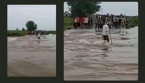
In India, the continuous droughts from 2013-15 were attributed to El Nino. La Nina has historically been associated with higher monsoon rainfall in India, and even the danger of cyclones on the east coast.
The latest El Nino was one of the strongest and ended in June 2016. The record high temperatures over the last year have been partly attributed to it (besides global warming).
What exactly does El Nino do?
El Nino causes warming of waters along Peru and Ecuador, typically in end December. However, this warm water changes the air current running over the United States of America, known as the southern jet stream. It pushes the current upwards, causing droughts in central USA.
But El Nino is also known to weaken the monsoon over India, by affecting the air circulation and water temperatures in the Indian Ocean. La Nina, being the opposite, causes higher rainfall.
La Nina's arrival was confirmed by US National Ocean and Atmospheric Administration (NOAA) on 10 November. In a statement titled "Hello La Nina", the agency said that It was expected to set in in the middle of the year.
Indian met department had also expected it to arrive in mid-2016, which it took into account while expecting the monsoon to be 106% of the long-period average. But the La Nina did not eventually arrive, and the monsoons turned out to be slightly lower at 97% of normal.
Hopes on La Nina
However, hopes for La Nina was rekindled after the NOAA's temperature index for the Pacific Ocean reported temperature deviation was more than 0.5 degrees C below the long-term average. The index was at -0.8C for two "overlapping seasons", July-September and August-October.
With this, there's a 55% chance that this will continue for another three "overlapping seasons" - the period which would constitute a full La Nina.
The NOAA's confirmation raises hopes of better rainfall in the next monsoon.
"Once the La Nina sets in, it will remain that way for 5-6 months. Although it is too early to say, the next monsoon would likely be normal or above normal because of this. It will not be a drought year," said Mahesh Palawat, chief meteorologist at Skymet Weather.
La Nina also causes warming of water in the Bay of Bengal. This can cause depression and cyclones. That leads to higher rainfall in Andhra Pradesh and Odisha.
After the La Nina failed, the IMD had expected a normal northeast monsoon, which lasts from October to December. However, the forecasts could be reworked based on the latest La Nina confirmation.
"La Nina's impact on the northeast monsoon is still being studied and there are no estimates on whether it will affect it," Palawat said.
First published: 13 November 2016, 3:33 IST


![BJP's Kapil Mishra recreates Shankar Mahadevan’s ‘Breathless’ song to highlight Delhi pollution [WATCH]](https://images.catchnews.com/upload/2022/11/03/kapil-mishra_240884_300x172.png "BJP's Kapil Mishra recreates Shankar Mahadevan’s ‘Breathless’ song to highlight Delhi pollution [WATCH]")

![Anupam Kher shares pictures of his toned body on 67th birthday [MUST SEE]](https://images.catchnews.com/upload/2022/03/07/Anupam_kher_231145_300x172.jpg "Anupam Kher shares pictures of his toned body on 67th birthday [MUST SEE]")


